The media’s favorite disaster script is playing out right now on the US Pacific islands.
"Very dangerous Super Typhoon barrels towards coast with 280 kmph winds." You have seen the headlines. You have seen the flashing red graphics on weather apps. The standard narrative is perfectly designed to induce maximum panic: a monstrous, unprecedented anomaly of nature is hunting down innocent territory, and total devastation is guaranteed.
It is a great narrative for driving clicks. It is a terrible way to understand atmospheric physics or actual risk management.
As someone who has analyzed meteorological data and emergency response frameworks during severe weather anomalies for over a decade, I am tired of the lazy consensus. Cable news networks treat wind speed like the score of a video game—the higher the number, the more terrifying the monster.
They are missing the point entirely. Focusing on peak wind velocity is a fundamentally flawed way to measure a tropical cyclone's true threat.
Here is the truth nobody admits: The 280 kmph headline is a distraction. The real danger has almost nothing to do with the wind, and the way we communicate storm risk is actively making communities less safe.
The Wind Speed Obsession is a Deadly Distortion
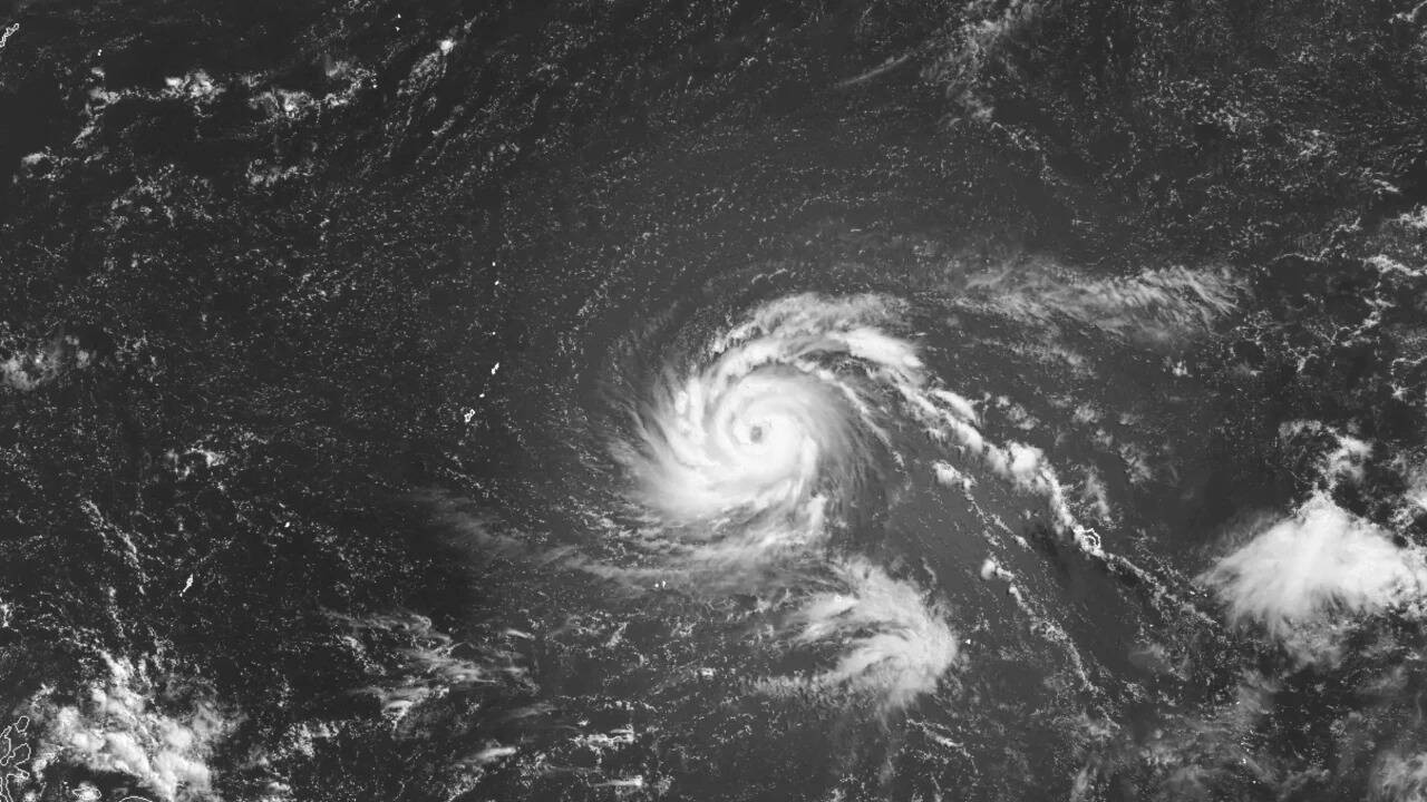
Let us break down the mechanics. The Saffir-Simpson scale (and its international equivalents) categorizes storms based almost exclusively on sustained wind speeds. A Super Typhoon hitting 280 kmph sounds like an apocalyptic wall of wind that will shave concrete structures clean off their foundations.
It does not happen that way.
First, those extreme wind speeds are recorded in the eyewall—a highly localized, rotating band of clouds immediately surrounding the center of the storm. The actual geographic footprint of 280 kmph winds is incredibly small. By the time those winds interact with the rough topography of a Pacific island, friction immediately degrades their velocity.
Second, modern building codes on US Pacific territories like Guam are engineered to withstand immense structural loads. The military installations and concrete residential structures built under Unified Facilities Criteria are tough. They do not blow away.
So why does the media obsess over wind? Because it is cinematic.
By hyper-focusing on wind velocity, the public is conditioned to look at the sky. They worry about roofs blowing off. Meanwhile, the actual killers arrive quietly at ground level: storm surge and localized torrential rainfall.
Data from the National Oceanic and Atmospheric Administration (NOAA) consistently shows that water, not wind, accounts for nearly 90% of all tropical cyclone deaths. Storm surge—the literal pushing of the ocean onto land by the storm’s low pressure and cyclic momentum—and inland flooding are the true hazards.
A slow-moving Category 2 storm dropping 50 inches of rain causes vastly more economic ruin and loss of life than a fast-moving Super Typhoon with 280 kmph winds that grazes an island over the course of three hours. Yet, the Category 2 storm gets a footnote, while the Super Typhoon gets a breaking news banner. We are tracking the wrong metric.
The Perverse Economics of Disaster Reporting
I have seen regional governments and private enterprises misallocate millions of dollars because they bought into the media’s panicked forecasting model.
When a "Super Typhoon" is declared, the immediate response is a massive, chaotic rush to evacuate or shutter operations. Supply chains fracture. Resources are deployed frantically to areas that do not need them, simply because those areas happen to fall under the projected path of the peak wind grid.
Imagine a scenario where a territory spends its entire emergency reserve budget deploying tactical teams to secure high-rise structures against wind damage, only to have the storm shift ten miles left, stall out over a low-lying valley, and drown an entire agricultural sector due to unmonitored flash flooding. That is the cost of chasing headlines instead of data.
The contrarian reality is that we need to stop treating these storms as unpredictable monsters. They are highly structured heat engines. They follow thermodynamic principles.
When the media shouts that a storm is "barreling" toward an island, they imply a straight, targeted line. In reality, cyclones operate within complex steering currents controlled by subtropical ridges and planetary-scale troughs. They wobble. They undergo eyewall replacement cycles that can cause a storm's peak winds to drop by 50 kmph in a matter of hours, even while the total size of the storm expands.
By framing every major tropical system as a historic catastrophe, meteorologists create alarm fatigue. When the 280 kmph winds inevitably fail to materialize inland because of mechanical friction and topography, the public assumes the scientists lied. The next time a genuinely anomalous water-borne threat approaches, people stay put. Panic-mongering destroys credibility.
Stop Asking When the Storm Will Hit
If you want to survive a major meteorological event, you have to change the questions you ask.
The typical citizen looks at the tracking map and asks, "When will the eye pass over my city?"
This is the wrong question. The eye is irrelevant to your safety. You should be asking: "What is the hydrological vulnerability of my immediate basin, and what is the forward speed of the system?"
A storm moving at 30 kmph distributes its rainfall over a massive geographic track, mitigating flood risk. A storm moving at 5 kmph acts as a stationary water tower, dumping billions of gallons onto the same square mile for days. The forward propagation speed of the storm matters infinitely more than the maximum sustained wind speed inside the eyewall.
Here is the actionable, unconventional approach to storm readiness that the standard news cycle will never give you:
- Ignore the Category: Stop looking at whether a storm is a Category 4 or a Super Typhoon. Look at the integrated kinetic energy (IKE). IKE measures the total structural wind field and physical size of the storm, which gives a far more accurate prediction of storm surge potential than a single wind measurement at the center.
- Track the Highs, Not the Lows: Do not just look at the storm icon on the map. Look at the high-pressure systems sitting above it. If a strong high-pressure ridge is parked to the north, the storm cannot escape. It will be forced to dump water until that ridge moves.
- Assume Infrastructure Failure Over Structural Destruction: Your house probably will not blow down if it is built of reinforced concrete. But your local power grid, water treatment facilities, and subsea data cables are highly vulnerable. Prepare for the failure of the systems around you, not the failure of the roof above you.
Admittedly, this analytical approach has a downside. It requires patience. It requires looking at boring pressure gradient charts and sea-surface temperature anomalies instead of watching a reporter get blown sideways on a beach. It forces you to accept that total safety is an illusion, and that mitigation is about cold, hard probability rather than emotional panic.
The corporate media needs the storm to be a monster because monsters generate revenue. But meteorology is a science of fluid dynamics, not a horror movie.
Stop buying into the theater of 280 kmph winds. Turn off the television broadcasts, look at the actual hydrological data, and realize that the real threat isn't the wind screaming through the air—it is the water rising silently at your feet.