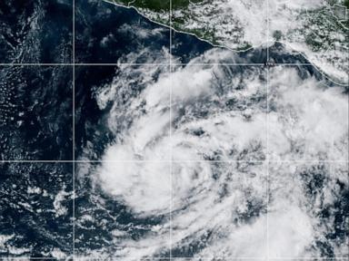
When Tropical Storm Vance formed in the eastern Pacific Ocean on October 21, 2026, it looked like a routine late-season bulletin from the National Hurricane Center (NHC). Initial advisories placed the system roughly 520 miles (835 kilometers) south of Acapulco, Mexico, with maximum sustained winds near 40 mph (65 kph) and no immediate threat to land.
Short wire stories love stopping right there. At sea. No landfall yet. Winds at the lower end of tropical-storm strength.
Honestly, that misses the whole point of watching an October system spin up south of Mexico. Late-season cyclones in the eastern Pacific have a habit of testing forecasters right as the basin transitions toward quieter autumn waters—and Vance ended up lasting from October 21 through October 30, climbing well past its initial 40 mph threshold before weakening.
Why Tropical Storm Vance Matters Beyond Its First Advisory
A tropical cyclone earns tropical-storm status once maximum sustained winds hit 39 mph. On paper, 40 mph doesn't sound dramatic. Out on open water, though, a newly organized circulation hundreds of miles off southern Mexico is already stirring rough swells, shifting wind fields, and signaling that atmospheric conditions are still favorable for organization even in the third week of October.
People often assume that once October rolls around, eastern Pacific hurricane activity is basically winding down. Sometimes it does. Sometimes it doesn't.
Meteorologists look closely at two things when a system like Vance forms late in the season. First, sea-surface temperatures and mid-level moisture have to cooperate enough to sustain deep convection near the storm's center. Second, steering currents and vertical wind shear decide whether a cyclone stays out to sea, curves toward cooler waters, or drifts closer to the Mexican coast.
A storm starting 520 miles south of Acapulco with 40 mph winds isn't a non-event—it's an early indicator of how much energy remains in the basin.
Over its roughly nine-day run through late October 2026, Vance evolved into a major hurricane on the Saffir-Simpson scale, peaking with winds around 110 mph and a minimum central pressure near 965 millibars before dropping back to a remnant low by October 30. You don't get that kind of longevity or intensity jump from ignoring a system just because its opening advisory sounds mild.
How Forecasters Track Pacific Cyclones Like Vance
Tracking a storm in the eastern Pacific looks straightforward on a phone screen—a dot, a cone, a wind speed. Behind that graphic is a constant tug-of-war between satellite imagery, ocean buoys, surface observations, and computer models trying to resolve convective bursts.
When a cyclone sits hundreds of miles offshore, forecasters rely heavily on geostationary and polar-orbiting satellites to judge center placement and cloud-top cooling. Microwave passes help peer beneath upper-level cirrus shields to see whether an eyewall or inner core is tightening.
Here's where people usually trip up when reading an NHC advisory:
- Maximum sustained winds apply to a narrow band, not the entire ocean. Even when a storm is rated a tropical storm or hurricane, gale-force or tropical-storm-force winds can stretch unevenly across quadrants depending on shear and storm motion.
- No immediate land threat isn't the same as zero coastal impact. Long-period swells generated offshore can travel hundreds of miles ahead of a system, creating dangerous rip currents and rough surf along beaches long before—or even if—the center never makes landfall.
- Forecast cones show track uncertainty, not storm size. A narrower cone later in a season doesn't mean intensity forecasts are effortless; rapid intensification or sudden weakening near cooler water or rough terrain can still surprise casual observers.
I've watched plenty of readers skim "posed no threat to land" and tune out completely, only to get caught off guard days later when swells build or forecast tracks shift northward. Reading the full advisory text—not just the headline—saves a lot of guesswork.
Past Storms Named Vance Show Different Paths
Hearing a storm name like Vance can also trigger confusion because tropical cyclone names recycle on set lists rather than belonging to one single storm. In the eastern Pacific, the name Vance has appeared more than once over the decades, and each storm took its own course.
Historical records show earlier eastern Pacific storms named Vance in 1990—which stayed away from land—and 2014, when Hurricane Vance reached Category 2 strength and affected Mexico, alongside the 2026 storm. Outside the eastern Pacific, the name was also used in the Australian region of the South Pacific in 1999, where Cyclone Vance caused heavy damage in Western Australia.
Comparing those storms side by side makes one lesson pretty clear. A name tells you nothing about where a cyclone will go or how it will behave. Ocean heat, shear, and timing do the talking every single time.
What to Watch When a Pacific Storm Forms
If you're following a storm like Tropical Storm Vance—whether you live near the coast, travel in the region, or just like tracking weather—skip the clickbait threads and stick to primary meteorological sources like the National Hurricane Center. Check the advisory time stamp first so you know whether you're reading a fresh update or stale news from twelve hours ago.
Next, look past the headline wind number and check three practical details: the storm's forward speed and direction, the latest forecast track and intensity discussion, and any marine or coastal advisories issued for your specific stretch of shoreline. If you're planning coastal travel or boat movement during active Pacific tropical weather, build buffer days into your schedule early rather than waiting until watches are posted.
AP News coverage of Tropical Storm Vance forming in the Pacific Ocean provides timely video context on how the storm developed and was expected to intensify in the Pacific basin.