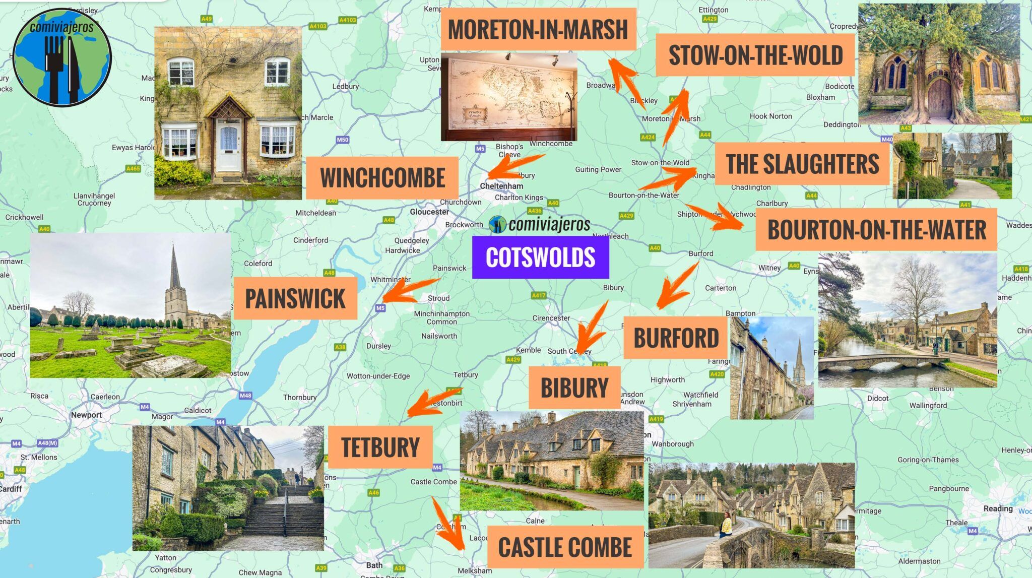
Executing a high-density regional itinerary within a constrained 36-hour operational window requires treating geography as a resource allocation problem rather than a leisure exercise. The Cotswolds region covers approximately 800 square miles across five counties, characterized by narrow limestone arteries, single-track agricultural lanes, and dispersed settlement clusters built during the wool trade boom of the Middle Ages. Standard leisure planning fails here because it assumes linear travel times between visual assets. In practice, logistical friction, rural parking capacity constraints, and peak density bottlenecks routinely degrade travel efficiency by up to 40 percent.
Solving this spatial optimization problem demands a framework based on geographic clustering, strict timing governance, and the minimization of back-track transit. By categorizing the region into distinct operational nodes based on historic preservation density and infrastructural capacity, travelers can maximize exposure time while keeping transit overhead below standard operational thresholds.
The Spatial Constraint Model
The primary bottleneck in regional touring is the transit-to-exposure ratio. Visitors frequently attempt to sample villages across the entire northern, central, and southern zones within a single weekend, resulting in excessive time spent navigating the B-roads of Gloucestershire and Oxfordshire.
The structural layout of the region consists of limestone valleys running roughly north-to-south, intersected by narrow cross-valleys. This topography dictates that east-west transit requires descending and ascending steep gradients on roads poorly designed for modern vehicle widths. Consequently, moving from a western hub like Chipping Campden to an eastern node like Burford introduces unnecessary friction unless routed through deliberate geographic corridors.
To optimize a 36-hour window, the geographic operational area must be restricted to a single high-density corridor. The northern corridor—anchored by Chipping Campden, Broadway, and Stow-on-the-Wold—offers the highest concentration of preserved vernacular architecture, distinct topography, and necessary hospitality infrastructure within a tightly bound fifteen-mile radius. This containment strategy neutralizes the primary variable of unmanaged transit delay.
Phase One Node Optimization The Northern Corridor
Operation within the northern corridor begins at dawn to exploit zero-density conditions in high-traffic nodes. Villages like Broadway and Chipping Campden exhibit severe parking capacity constraints by mid-morning, driven by regional bus excursions and concentrated private vehicular traffic.
Chipping Campden serves as the architectural baseline for the northern cluster. The High Street demonstrates the evolution of Cotswold domestic architecture, constructed from Jurassic limestone quarried locally—specifically Inferior Oolite. The economic engine of this settlement historically relied on the wool trade, which funded the perpendicular gothic architecture of St James Church. Analyzing the built environment reveals the correlation between wool merchant capital and urban permanence. The proportional wealth of the 15th-century staple merchants directly dictated the structural integrity and decorative stone masonry that modern visitors observe.
Moving eastward via the B4032 to Broadway Tower introduces an elevated geographic perspective. Situated on the second-highest point of the Cotswolds at 1,024 feet above sea level, this 18th-century folly provides a topographical baseline of the region. From an analytical perspective, understanding the visual dominance of this ridge clarifies why historical settlement patterns avoided exposed high ground in favor of sheltered valley floors near river systems such as the River Evenlode and the River Windrush. Valley siting provided immediate access to water power for milling and protection from prevailing westerly winds, whereas the ridges functioned primarily as defensive or communication outposts.
Phase Two Temporal Sequencing and Economic Nodes
As morning transitions into peak operational hours, transit must shift away from residential cores toward commercial and transitional hubs. Stow-on-the-Wold represents a departure from the valley-floor settlement pattern. Built on a hill top at the intersection of several ancient trade routes, including the Roman Fosse Way, Stow was historically designed as a market town rather than a residential parish.
The central square reflects this commercial genesis, engineered explicitly to contain large livestock markets. The surrounding alleyways, known locally as "tucks," were designed to funnel sheep efficiently. Modern visitors often misinterpret these tight urban corridors as aesthetic design choices when they are actually functional logistical infrastructure from the medieval wool economy.
Navigating Stow during peak hours requires strict adherence to parking protocols. The central square operates under strict municipal limits, and secondary municipal lots require physical or digital ticket validation. Ignoring these minor regulatory controls introduces friction that disrupts the tight temporal sequencing required for a 36-hour timeline.
Following the Fosse Way south leads to lower-density agrarian nodes that require a different observational approach. Villages such as Lower Slaughter and Upper Slaughter provide a clear case study in water management and vernacular industrialization. The River Eye bisects these settlements, powering historical corn mills that remained operational well into the 20th century. The spatial organization here demonstrates how early industrial clustering relied entirely on micro-hydrology. The placement of the Manor House relative to the mill race highlights the feudal control over energy production sources within the local economy.
Operational Friction and Resource Allocation
Executing this itinerary without schedule degradation requires addressing three persistent failure points: parking availability, dining bottlenecks, and digital connectivity deficits.
Rural mobile data coverage across the Cotswolds is notoriously inconsistent, particularly within steep limestone valleys where cellular towers fail to penetrate the topography. Relying on real-time cloud navigation can result in operational paralysis if a route becomes blocked by agricultural machinery or local events. Offline map caching of the entire northern corridor is mandatory prior to departure.
Dining infrastructure presents the second major operational hazard. Traditional pubs and high-end eateries operate under strict kitchen hours that close significantly earlier than urban equivalents. Attempting an ad-hoc dining strategy during peak tourist seasons invariably results in extended wait times that cascade through the remainder of the schedule. Reservations must be secured weeks in advance, or travelers must transition to a self-catered logistics model using local artisanal providores found in hubs like Moreton-in-Marsh.
Parking capacity operates on a strict diminishing returns curve. Arriving at primary visual assets after 10:00 AM shifts the time cost of parking from a negligible two-minute transition to a thirty-to-forty-minute search pattern. The counter-strategy is temporal shifting: reserve visual nodes with high tourist density for the earliest operational hours (06:00 to 08:30) and utilize mid-day periods for transit between nodes or dining engagements.
Final Resource Deployment Strategy
To maximize the output of a 36-hour operational window in the Cotswolds, abandon the mindset of comprehensive regional coverage. Treat the landscape as a localized case study in medieval economic history, vernacular architecture, and rural geography. Lock the itinerary strictly within the northern cluster to eliminate transit friction, enforce early-morning temporal deployment to bypass infrastructure bottlenecks, and rely on offline spatial data to insulate against rural connectivity failures. The value of the region lies not in the velocity of movement across counties, but in the analytical depth extracted from a single, well-optimized geographic corridor.