Listen.
Before the wind even picks up speed along Mexico's Pacific coast, you hear it in the water first, a deep, hollow thudding against the pilings that feels less like weather and more like an approaching train beneath the floorboards.
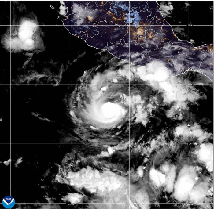
On a weather map, a storm strengthening to Category 3 looks tidy. A neat spiral of white clouds over blue water. A number on a scale. Sustained winds reaching 111 to 129 mph on the Saffir-Simpson Hurricane Wind Scale, enough to snap shallow-rooted trees, strip roofs from poorly anchored buildings, and turn loose patio furniture or corrugated sheet metal into spinning blades.
Numbers are easy to read on a glowing screen. They are much harder to hold onto when salt spray stings your eyes at two in the morning and the power grid flickers out for good.
To understand what happens when a storm reaches major hurricane strength off Mexico's western shore, we have to look past the satellite loop and trace how pressure, warm ocean water, and steep coastal geography collide with ordinary lives. Because what looks like a clean meteorological upgrade on a forecast bulletin is really a shift in physics, timing, and risk.
The Quiet Shift From Warning to Danger
Storms do not always announce their sharpest leaps with dramatic fanfare. Often, a tropical cyclone sits offshore, gathering heat from warm Pacific waters, while people on land try to make sense of conflicting advice. Some pack immediately. Others wait for one more update, hoping the system wobbles harmlessly out to sea or weakens before coming near the coast.
Meteorologically, reaching Category 3 is a major threshold. Below that mark, winds can still cause serious harm, flood low streets, and down power lines, yet many sturdy structures keep their roofing and walls intact. At Category 3 and above, wind forces rise steeply—remembering that wind pressure increases roughly with the square of wind speed, so a jump in wind velocity hits buildings and trees with far more force than casual math suggests.
Think of it like standing in front of a garden hose versus standing in front of a pressure washer. Both spray water. Only one tears paint off siding and sends loose gravel flying.
Here is a hypothetical scenario to ground those numbers on the ground. Picture Elena, who runs a small family seafood kitchen a few blocks inland from a Pacific fishing cove in southern or southwestern Mexico. All afternoon, the sky has held a strange, milky hush, the kind of stillness where pelicans stop gliding and tuck into sheltered coves. By dusk, local radio bulletins confirm the storm has intensified to Category 3 offshore. Elena has shutters to bar, an ice chest to secure, and an elderly neighbor across the lane who refuses to leave until the rain actually starts falling.
That delay—waiting until the rain starts—is one of the oldest traps in coastal weather. By the time heavy bands arrive and swell pushes into the harbor mouth, roads flood quickly, visibility drops to a few yards, and moving a car or helping someone on foot becomes far more hazardous than it was two hours earlier.
Why the Pacific Coast Carries Its Own Risks
People sometimes lump eastern Pacific storms together with Atlantic hurricanes, assuming the mechanics and hazards play out the same way. They share the same basic engine—warm ocean surface temperatures fueling rising moist air, low vertical wind shear allowing the circulation to organize, and an inner eyewall tightening as barometric pressure drops.
Yet Mexico's Pacific coastline has a distinct personality.
First, the mountains rise close to the sea in many stretches. Where warm, moisture-laden air from a major hurricane is pushed inland and forced upward over rugged terrain, rainfall can become torrential even if the storm center clips the coast or stays just offshore. Heavy rain on steep slopes turns dry gullies into rushing brown torrents and loosens saturated soil, creating mudslide and flash-flood hazards far from the beach.
Second, the continental shelf along much of Mexico's Pacific coast is relatively narrow compared with some broader shelves elsewhere. A narrow shelf often limits extreme surge amplification in certain spots compared with wide, shallow bays, yet powerful long-period swells still race ahead of the storm for hundreds of miles. Long before the eyewall arrives, dangerous rip currents and heavy surf batter piers, marinas, and low-lying promenades.
Consider what happens next when a Category 3 system threads the needle between open ocean and coastline. Even if the exact point of landfall—or closest approach—shifts by thirty or fifty miles, coastal communities across a wide swath feel the consequences. Outer rainbands lash towns miles from the center. Swells roll ashore under gray skies. Supply trucks slow down on slick highway curves.
Why does a forecast track always show a cone of uncertainty rather than a single thin line? Because a hurricane is not a bullet fired from a rifle; it is a massive, shifting wheel of air and water steered by broader atmospheric currents that forecasters measure imperfectly over open ocean. A slight wobble in steering winds or a sudden burst of inner-core organization can change local impacts faster than people expect.
What People Usually Ask When a Category 3 Forms
When news breaks that a storm off Mexico's Pacific coast has reached Category 3, the questions people ask are rarely abstract. They are immediate, practical, and tinged with worry.
Does Category 3 mean guaranteed catastrophic destruction everywhere along the coast?
No, and pretending every mile of coastline faces identical damage distorts reality. A major hurricane carries severe destructive potential, especially near the eyewall and along the side where forward motion adds to wind speed. Yet impacts vary sharply depending on local topography, elevation, building construction, distance from the core, and whether the storm stays offshore or makes a direct hit. Treating a forecast as either "nothing will happen" or "everything is doomed" leads people to make poor choices—either staying put in a vulnerable spot or panicking without a plan.
How fast can a storm intensify before reaching land?
Rapid intensification—commonly defined by meteorologists as an increase in maximum sustained winds of at least 35 mph within a 24-hour period—can catch communities off guard when warm water and favorable upper-level outflow align. A tropical storm or Category 1 system can climb into major hurricane territory faster than someone who checked the forecast over morning coffee realizes. That is why officials stress acting on watch and warning timelines rather than waiting for final confirmation at the eleventh hour.
Is wind the biggest threat from a major Pacific storm?
Not always. Strong winds grab headlines and snap trees and power lines, but water—from heavy rainfall runoff, flash flooding in arroyos and low streets, and pounding coastal surf—frequently causes widespread disruption and danger inland and along the shore alike. A storm that weakens slightly before coming ashore or brushes past the coast can still dump staggering amounts of rain over hilly terrain.
I have stood by coastal water after heavy squalls and felt how deceptive calm air can be right between bands. One minute you hear dripping leaves and distant traffic; ten minutes later, horizontal rain stings your neck and branches whip sideways like whips. Respecting that gap—using calm hours to finish preparations rather than assuming the worst is over—separates people who ride out trouble from people caught scrambling in the dark.
The Invisible Stakes Behind Every Bulletin
Behind every headline about a Category 3 storm off Mexico's Pacific coast are ordinary, unglamorous things that keep daily life stitched together.
Fishing pangas pulled up onto sand or tied with extra lines so they do not smash against concrete walls. Small grocers deciding whether to run a noisy generator to save milk and meat or save fuel for the next week. School administrators weighing whether buses can safely cross low bridges before afternoon downpours swell creeks. Families checking on relatives whose homes sit on hillsides or near riverbanks.
(Here is a metaphor to make that web easier to picture: a coastal town is like a woven hammock strung between trees—when a strong gust hits one corner, the pull is felt across the whole weave.)
Forecasting has come a long way. Satellites track cloud tops and ocean heat content around the clock, aircraft fly into storms when conditions and missions allow, and computer models simulate atmospheric pressure and wind fields continuously. Yet technology only works if the warning reaches people in plain language and translates into timely action before roads flood or cell towers lose backup power.
Uncertainty never disappears completely in weather. Any honest forecaster or emergency planner knows that nature keeps a margin of surprise—a sudden jog north, a tighter wind core, a heavier rainband than modeled. Admitting that uncertainty is not weakness; it is the whole reason preparation starts early instead of waiting for certainty that may arrive too late.
When the wind finally eases and the clouds break into pale gold over the Pacific, the story on screens often moves on quickly to the next system or the next headline. For the people along the coast, the real test often begins right then: clearing downed limbs, navigating washed-out roads, drying soaked rooms, and waiting for light and water to return.
Out past the reef, the swell keeps rolling in, long and dark and heavy, carrying the memory of all that energy across open water long after the sky begins to clear.